
When a tropical storm forms in the Atlantic or Gulf of Mexico, a set of urgent questions ripples through boardrooms and operations centers across Texas. Where is it headed? When will it arrive? What are the potential impacts on our personnel, supply chain, and physical assets?
Obtaining reliable answers requires more than just monitoring news reports—it demands data-driven foresight. For many seasoned business leaders in sectors from Energy to Logistics, a primary tool for early guidance is the euro hurricane model.
The Euro model, officially produced by the European Centre for Medium-Range Weather Forecasts (ECMWF), is not a crystal ball. It is a sophisticated risk-mapping tool that has earned a strong reputation for its proficiency in predicting a hurricane's path, or "track," several days in advance.
This track forecast is the foundation of any robust operational continuity plan. For a logistics company managing fleets along the I-10 corridor, it is the signal to begin formulating rerouting strategies. For a coastal petrochemical facility near Houston, it is the trigger to review shutdown procedures and timelines. The model’s reliability provides the crucial lead time needed to make these high-stakes decisions strategically, not reactively.
Why Is Track Forecasting So Important for Texas Industries?
A hurricane's path dictates which fixed assets and operational hubs are in the direct line of a storm's most severe impacts. For industries with high-value, immovable infrastructure—such as energy refining, manufacturing plants, and large-scale construction projects—knowing the likely landfall area is paramount for risk mitigation.
The Euro model’s data provides decision-makers with the foresight to:
- Anticipate Supply Chain Disruptions: Assess potential impacts on key transportation arteries, from interstate highways to critical shipping channels in the Port of Houston and Corpus Christi.
- Manage Physical Assets: Schedule the lockdown of construction sites, the relocation of agricultural equipment, or the securing of manufacturing facilities based on the storm's projected arrival.
- Ensure Personnel Safety: Develop and communicate clear evacuation or shelter-in-place plans for employees within the forecast cone of uncertainty, in compliance with local emergency management directives.
The core value of the Euro model for Texas businesses is its ability to provide a consistent and generally reliable forecast of a hurricane's future track, enabling leaders to shift from a reactive to a proactive risk management posture.
Here’s a quick-reference guide breaking down what the Euro model really means for operational planning in Texas.
The Euro Model's Core Features for Business Leaders
| Forecasting Aspect | Euro Model Performance | Implication for Texas Businesses |
|---|---|---|
| Track Forecasting (Path) | Generally considered an industry leader for 3-7 day forecasts. | Provides the critical lead time needed for strategic rerouting, facility shutdowns, and supply chain adjustments. |
| Intensity Forecasting (Strength) | Historically less consistent than its track forecasts; can sometimes underestimate rapid intensification over the Gulf of Mexico. | Track data is reliable for location-based planning, but intensity forecasts must be cross-referenced with other models and official NHC guidance for asset hardening decisions. |
| Global Coverage | A global model, meaning it accounts for weather systems worldwide that can influence a hurricane's path. | Its broad view often captures complex steering currents that other, more localized models might miss, improving long-range track accuracy. |
| Update Frequency | Runs twice daily (00z and 12z). | Businesses receive major forecast updates every 12 hours, which is less frequent than some American models but provides a stable, comprehensive picture for strategic planning. |
While the Euro is an indispensable tool, it's just one piece of the puzzle. It is critical for executives to remember that no single model is perfect. To get a wider view on how these complex systems operate, you can explore our detailed guide on different types of weather computer models.
The most prudent risk management approach is to use the Euro model's data alongside other top-tier forecasts. This creates a more complete and nuanced picture of the potential operational risks, allowing for more confident and effective decision-making.
Disclaimer: ClimateRiskNow does not sell insurance or financial products. The information provided in this article is for educational and operational planning purposes only and should not be interpreted as financial advice or an insurance recommendation.
How the Euro Model Predicts a Hurricane's Path
To understand the Euro hurricane model's impressive track record, it is helpful to view it not as a simple prediction, but as a massive, four-dimensional simulation of our planet’s entire atmosphere. This is a monumental data-processing operation that starts with one critical goal: to create the most accurate "snapshot" possible of what global weather is doing right now. From that starting point, the model applies complex physics to project how the atmosphere will evolve.
The quality of that initial snapshot is what really sets the Euro model, or ECMWF, apart. It ingests an enormous amount of information from a worldwide network of sources, including satellites providing a top-down view, ocean buoys reporting sea surface temperatures that act as storm fuel, and weather balloons transmitting real-time atmospheric conditions from various altitudes.
This process of feeding live data into the model is called data assimilation. The Euro model’s system is widely considered a top performer at blending all these different observations into a single, coherent picture of the present. A better starting point almost always leads to a more reliable forecast.
The Building Blocks of an Accurate Forecast
The model’s predictive capability comes from two key components: its high-resolution grid and its sophisticated data assimilation.
The model divides the entire globe into a fine grid, with data points spaced approximately 9 kilometers (about 5.6 miles) apart. This high resolution allows it to "see" smaller-scale weather features that can steer a hurricane—details that lower-resolution models might simply smooth over.
Consider a map of the Texas coastline. A map with points every 10 miles provides a rough outline. But a map with points every half-mile captures the intricate details of Galveston Bay or the Corpus Christi ship channel. The Euro model's high-resolution grid works the same way, giving it a more detailed and nuanced view of the atmospheric forces at play. This is a significant reason for its well-earned reputation in predicting a storm's landfall location.
The graphic below breaks down the key data sources that fuel the Euro hurricane model's predictions.
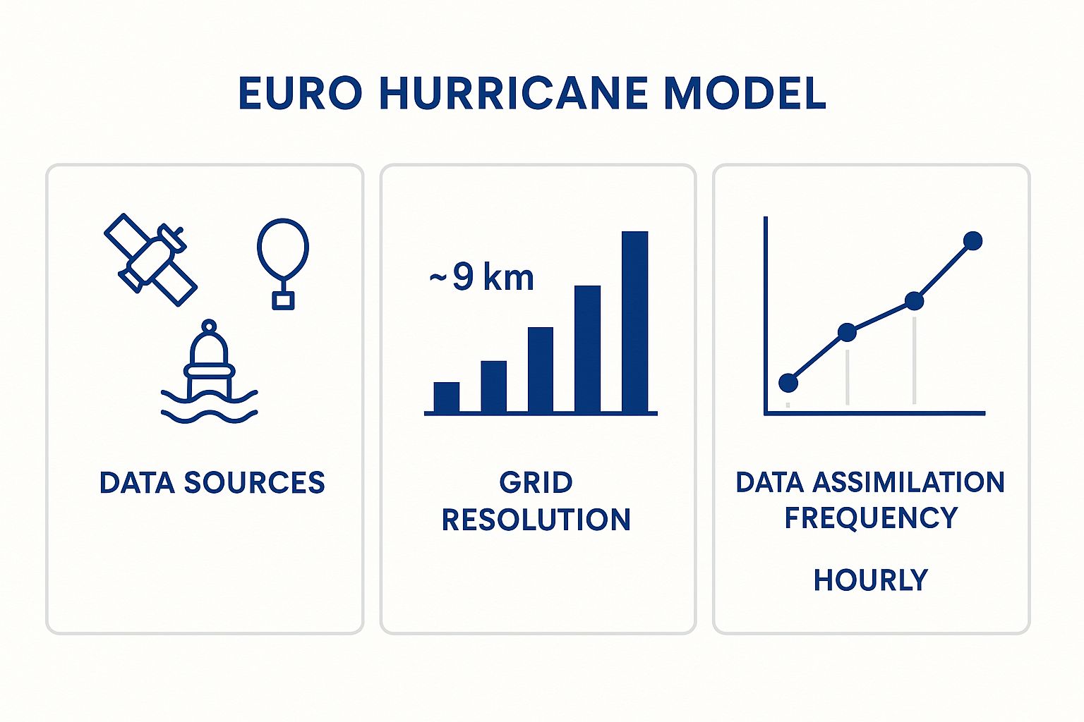
This process highlights how the model’s detailed grid and constant data updates come together to create a more complete and accurate atmospheric picture.
Turning Data Points into a Projected Path
Once the initial conditions are locked in, the model's supercomputers run complex simulations to project the weather forward in time. For Texas businesses—from construction managers in Houston to logistics coordinators in Dallas—this is where the data becomes actionable. The output is visualized on the what weather maps tell you that are commonly seen in forecast products. The familiar "spaghetti plots" show various potential paths, and the cone of uncertainty is built largely from this kind of forecast data.
The Euro model’s strength is not magic. It is the direct result of superior data collection, advanced assimilation techniques, and immense computational power. This combination generates a highly reliable forecast of a hurricane's future track, enabling business leaders to shift from a reactive to a proactive risk management posture.
This methodical, data-driven approach has yielded significant results. Over the last two decades, the accuracy of all hurricane track models has improved dramatically. According to official forecast verification trends from the National Hurricane Center, the 5-year average track forecast error for Atlantic hurricanes at 72 hours out has been cut from about 200 nautical miles in the early 2000s to under 100 nautical miles in recent years—a more than 50% improvement.
For decision-makers in Texas, this increased accuracy provides far greater confidence when activating contingency plans, rerouting supply chains, or making critical calls about personnel safety based on the Euro model's guidance.
Comparing the Euro Model With the American GFS Model
In hurricane forecasting, two names dominate the conversation: the Euro model (ECMWF) and the American model (GFS). For anyone making operational decisions in Texas when a storm is in the Gulf, understanding the practical differences between these two is essential for comprehensive risk assessment.
They are not interchangeable. Each model has distinct characteristics and strengths, and recognizing them can significantly improve the quality of your risk management strategy.
The primary distinction is rooted in performance history. Over many hurricane seasons, the Euro hurricane model has consistently demonstrated superior skill in predicting a storm's track—its path—several days out. It functions as a reliable long-range scout, providing a clearer picture of where the primary threat is likely to be directed.
Conversely, the American GFS (Global Forecast System), run by the U.S. National Weather Service, updates more frequently. This can sometimes give it an edge in capturing fast-developing situations, but its long-range track forecasts have historically been less consistent than the Euro's.
Core Differences in Methodology and Performance
The performance differences largely stem from their underlying architecture. The Euro model's advantage often comes from its massive supercomputing power and a more sophisticated data assimilation system.
In practical terms, it performs a more accurate job of taking the initial "snapshot" of the atmosphere. It ingests billions of data points from satellites, buoys, and aircraft to create a more robust starting point for its forecast. A better start almost always leads to a more reliable finish.
This has direct implications for Texas industries. A reliable 5-day track forecast from the Euro gives a logistics company the confidence to begin rerouting shipments away from the Port of Houston. It gives an energy firm the lead time to schedule preliminary checks on offshore platforms.
The outputs of both models are visible in the "spaghetti plots" issued by weather agencies, including the National Hurricane Center. The Euro is often labeled EMX or ECMWF, and the GFS is labeled as GFS or AEMN.
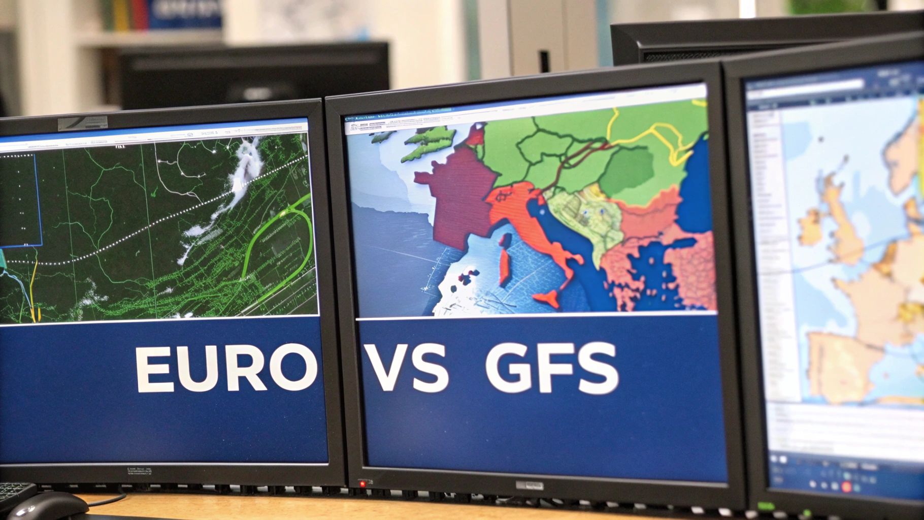
This image is a powerful reminder of why basing decisions on a single model is a high-risk strategy. The spread in those lines illustrates the inherent uncertainty in forecasting and underscores the need for a consensus-based approach.
To break it down further, here’s a practical comparison of how these two forecasting heavyweights stack up for businesses on the ground.
Euro (ECMWF) vs American (GFS) A Practical Comparison
A comparative analysis of the two leading global weather models, focusing on aspects crucial for operational decisions.
| Feature | Euro Hurricane Model (ECMWF) | American Hurricane Model (GFS) | Relevance for Texas Industries |
|---|---|---|---|
| Track Accuracy (3-7 Days) | Historically superior; often considered the industry benchmark for long-range path forecasting. | Generally good, but historically less consistent than the Euro model at longer ranges. | Critical for strategic planning: rerouting supply chains, scheduling shutdowns, and positioning assets ahead of a storm. |
| Update Frequency | Runs twice per day (00z and 12z). | Runs four times per day (00z, 06z, 12z, 18z). | GFS's more frequent updates can be useful for tactical, short-term decisions as a storm nears the coast. |
| Data Assimilation | Employs a highly advanced 4D-Var system, which is a key reason for its accuracy. | Uses a robust system but has historically lagged slightly behind the Euro's technology. | A better starting point (assimilation) means a more reliable forecast for making high-stakes financial and safety decisions. |
| Resolution & Detail | Generally offers higher resolution, providing more granular detail in its forecasts. | Has made significant improvements but sometimes lags the Euro in fine detail. | Higher resolution can help differentiate impacts between nearby locations, like facilities in Galveston vs. Freeport. |
This table is not about choosing a "winner" but about understanding the right tool for the job. Both models provide essential data points that, when used together, create a much clearer and more reliable picture of the impending risk.
Why a Consensus Forecast Is the Gold Standard
While the Euro model often earns top marks for track accuracy, no single model is infallible. There have been numerous storms where the GFS was more accurate than the Euro. This is precisely why experienced risk managers never base critical operational decisions on just one forecast.
Relying solely on one model, even a top performer like the Euro, introduces a significant and unnecessary operational risk. The most robust risk management strategies are built on a "consensus" forecast, which averages the outputs of several top-tier models.
A consensus approach smooths out the specific biases of any single model, delivering a more stable and trustworthy projection.
For instance, if the Euro shows a landfall near Galveston, the GFS points toward Corpus Christi, and other models fall in between, the consensus track will likely indicate a threat somewhere along the central Texas coast. This blended view is the foundation of the official National Hurricane Center (NHC) forecast. Understanding this is essential to getting the most accurate weather forecasts for your planning.
Imagine you're managing a construction company with major projects in both Houston and San Antonio. This nuanced, multi-model view is invaluable. It lets you prioritize securing the site with the highest collective risk instead of overreacting to the dramatic swings of a single model's latest run.
Ultimately, using both the Euro and American models as key inputs into a broader consensus strategy is the most effective way to turn complex weather data into clear, actionable intelligence.
Track vs. Intensity: A Critical Distinction for Risk Management
When a hurricane threatens Texas, business leaders need to know two things: where it is going (track) and how strong it will be when it gets there (intensity). Confusing these two distinct variables is a common error that can lead to catastrophic miscalculations in operational preparedness. A perfect track forecast is of little value if a business prepares for a Category 1 storm and a Category 3 causes extensive damage to its facility.
The Euro hurricane model (ECMWF) has earned its reputation by consistently providing reliable track forecasts. However, when it comes to predicting a storm's raw power—especially the rapid intensification that can occur over the warm waters of the Gulf of Mexico—it has a well-documented limitation. For any Texas industry, that discrepancy is a massive operational risk.
Consider the implications. A logistics firm might use the Euro’s track to brilliantly reroute its fleet away from a projected landfall in Freeport. But if a partner's manufacturing plant in that same area only hardens its facility for a minor storm—based on an under-forecasted intensity—the outcome could be devastating, leading to structural failure, prolonged downtime, and a shattered supply chain.
The Two Sides of a Hurricane Forecast
To make effective decisions, you must treat track and intensity as separate, equally vital pieces of intelligence. Each one demands a different operational response.
- Track Forecast (The "Where"): This is the storm's predicted path. It answers geographic questions like, "Is our facility in the potential impact zone?" and "Do we need to relocate mobile assets?" For this type of long-range strategic planning, the Euro model is a trusted tool.
- Intensity Forecast (The "How Strong"): This predicts the storm's maximum sustained wind speeds, which determines its Saffir-Simpson category. It answers threat-level questions like, "Can our buildings withstand the projected wind loads?" and "What level of shutdown protocol do we need to initiate?"
This is precisely where the Euro model’s limitations become a critical planning factor. While the ECMWF consistently ranks as a top performer for hurricane track forecasting, its ability to predict intensity has historically been less reliable. In head-to-head comparisons, the Euro model’s intensity forecast errors have often been larger than those from more specialized intensity models.
Operational Dangers of the Discrepancy
This gap between the Euro’s stellar track accuracy and its less consistent intensity forecasting can create a dangerous false sense of security. A decision-maker might see the track locked in days in advance and wrongly assume the predicted strength is just as certain, failing to cross-reference with other, more suitable models.
Relying on the Euro model for both track and intensity is like trusting a world-class navigator to also perform complex engineering analysis. It is an expert at plotting the course, but assessing the storm’s complex internal engine requires a specialist's tools.
Picture a major construction project on the Texas coast. The project manager sees the Euro’s accurate track and knows the site is in the path. The model’s initial forecast is for a tropical storm. Based on that, they might only secure loose materials. If that storm rapidly intensifies into a major hurricane overnight—a common occurrence in the Gulf—the project's cranes and unfinished structures become multi-million-dollar liabilities. This scenario underscores why understanding how wind is measured and categorized is so vital, as destructive force multiplies exponentially between categories.
This highlights the necessity of a multi-model approach. To get a complete, actionable risk picture, Texas executives must pair the Euro’s top-tier track guidance with data from specialized intensity models and, most importantly, anchor their final decisions to the official forecasts from the National Hurricane Center, which blends all of these data sources into the most reliable consensus forecast available.
Applying Euro Model Data to Your Operations

Forecast data is only valuable once it triggers action. For business leaders in Texas, the output from the Euro hurricane model is not just a weather map—it’s the backbone of a proactive operational response. The critical task is translating complex meteorological data into a clear, step-by-step playbook that safeguards assets, protects personnel, and ensures business continuity.
The most effective way to use the Euro model is to build a tiered response plan tied directly to the storm’s forecast timeline. This approach aligns your operational decisions with the forecast's confidence level. A long-range forecast triggers review and planning, while a short-range forecast demands immediate, decisive action.
Building a Tiered Response Protocol
A tiered system allows your organization to scale its response logically, avoiding premature costs and unnecessary disruptions. It establishes clear triggers for specific actions, which removes ambiguity when pressure is high.
This framework can be built around the Euro model’s 7-day, 5-day, and 3-day outlooks.
- 7-Day Outlook (Strategic Review): At this range, the model provides a broad alert about a potential threat. The focus is on situational awareness and initial planning reviews.
- 5-Day Outlook (Preliminary Actions): As the storm’s potential track becomes clearer, your team can begin taking low-cost, high-impact preparatory steps.
- 3-Day Outlook (Operational Activation): Inside of 72 hours, forecast accuracy improves significantly. This is the trigger to activate your most critical, resource-intensive procedures.
This tiered structure ensures every action is measured and appropriate for the level of risk. For a Texas company, this is how a complex forecast becomes a real operational advantage. Integrating this process with advanced data analytics is key to quantifying risks and sharpening strategic decisions. Businesses can learn more about these applications at https://www.climaterisknow.com/blog/data-analytics-for-insurance.
Actionable Examples for Texas Industries
Let's examine how this tiered framework translates into specific actions for key sectors in Texas. The goal is to move from abstract data to concrete decisions that protect your bottom line.
For a Logistics & Distribution Firm in Houston:
- 7-Day Trigger: The operations manager flags all shipments scheduled to pass through the potential impact zone. They also verify emergency communication channels with key clients and drivers.
- 5-Day Trigger: The team begins mapping alternate routes, planning detours around projected storm surge areas and vulnerable highways like I-10 and I-45. High-value, non-essential cargo is expedited out of the area.
- 3-Day Trigger: Alternative routes are activated. All non-essential fleet movement into the cone of uncertainty is halted. The company confirms that staging areas for post-storm recovery assets are well outside the impact zone.
For a Manufacturing Plant in Corpus Christi:
- 7-Day Trigger: The plant manager reviews the facility’s hurricane action plan with department heads. They assess inventories of raw materials and finished goods to identify potential supply chain vulnerabilities.
- 5-Day Trigger: Site preparation begins. Teams secure loose equipment, clear drainage systems, and test backup generators. Production on non-essential lines may be scaled down to reduce on-site inventory.
- 3-Day Trigger: A safe, orderly shutdown of all non-essential operations is initiated. The final shift is sent home, and the facility is secured to withstand projected wind loads and flooding.
By integrating these predictions, businesses can effectively use the Euro Model data for creating a robust disaster recovery plan to safeguard their operations and personnel. A well-defined plan, triggered by reliable data, removes guesswork and ensures a coordinated, effective response when it matters most.
This methodical approach is applicable across Texas’s major industries. An agricultural operation in the Rio Grande Valley might use a 5-day forecast to accelerate harvesting, while a construction firm in Galveston would use a 3-day forecast to lower and secure its cranes. The principle remains the same: use the data to act early, act strategically, and mitigate risk before the storm makes landfall.
Disclaimer: ClimateRiskNow does not sell insurance or financial products. The information provided is for educational purposes only and should not be interpreted as financial advice or an insurance recommendation.
The Bottom Line
For any Texas business leader monitoring the tropics, the Euro hurricane model is an indispensable part of the risk management toolkit. It is essential to understand both its strengths and its limitations. Its superior track forecasting provides the crucial lead time needed to make strategic decisions, whether that involves rerouting supply fleets or initiating a safe, orderly shutdown of a facility.
However, relying solely on the Euro model for storm intensity creates a dangerous blind spot in your operational planning.
The key takeaway is simple: no single weather model ever tells the whole story. A truly resilient operational plan uses the Euro model’s track guidance but layers it with data from specialized intensity models and, crucially, the official consensus forecast from the National Hurricane Center. This multi-model approach is the only way to effectively manage risk and turn a flood of complex weather data into a real operational advantage.
Important Disclaimer The information provided by ClimateRiskNow is for educational and operational planning purposes only and does not constitute financial advice. ClimateRiskNow does not sell insurance or financial products.
To continue building a more weather-resilient enterprise, explore our in-depth resources. Our guide on the most accurate weather forecasts can help sharpen your decision-making process, and our breakdown of how wind is measured provides the essential context needed to understand storm severity.
Frequently Asked Questions
When it comes to operational planning for hurricane season, understanding the tools at your disposal is critical. We often receive questions from Texas business leaders about the European hurricane model, so we have compiled practical answers to help you integrate it into your risk management strategy.
Why Is the Euro Model Often Considered More Accurate for Hurricane Tracks?
The European model, or ECMWF, has a strong reputation for track forecasting due to two key factors: it uses a higher-resolution grid and a more sophisticated data assimilation system. In essence, the Euro model takes a sharper, more detailed initial "snapshot" of the atmosphere's current state before it begins its forecast simulation.
That clearer starting point generally leads to a more reliable projection of a storm's path several days out. For a Texas business, this means a more trustworthy early assessment, which is crucial for making initial decisions about facility preparation or supply chain adjustments.
Can I Ignore Its Intensity Forecast if the Track Is Accurate?
No—making that assumption is a dangerous operational error. A storm's impact is a two-part equation: where it is going (track) and how strong it will be when it arrives (intensity). A facility could be perfectly prepared for the storm's location but be overwhelmed if a Category 4 storm arrives instead of a forecasted Category 1.
The best practice is to use the Euro's track guidance alongside specialized intensity models and, most importantly, the official forecasts from the National Hurricane Center. The NHC's forecast is the definitive source for decision-making.
Relying on the Euro for both track and intensity creates a critical blind spot in your operational plan. A storm's path dictates if you will be impacted, but its strength dictates the severity of that impact on your assets and personnel.
How Far in Advance Can I Reliably Use the Euro Model for Planning?
The Euro model's 5-to-7-day forecast is your window for strategic review. This is the time to assess emergency protocols, flag potential supply chain issues, and put your team on alert.
However, for high-cost, high-stakes operational decisions—such as shutting down a plant or evacuating a site—it is prudent to wait for the 3-day (72-hour) window. Inside this timeframe, the model's track accuracy improves dramatically, providing the confidence needed to commit significant resources. An effective response plan should be tiered, matching the level of action to the certainty of the forecast.
Does the Euro Model Account for the Gulf of Mexico Waters?
Yes, the model factors in global sea surface temperatures, including the warm, energy-rich waters of the Gulf of Mexico that fuel hurricanes. The challenge for all models, however, is predicting precisely when and how a storm will use that fuel to rapidly intensify.
This is why businesses on the Texas coast must monitor updates from the National Hurricane Center so closely. The NHC integrates real-time data from hurricane hunter aircraft and specialized local models to fine-tune its intensity forecasts. That localized data provides a level of detail that a global model like the Euro can sometimes miss, which is essential for assessing the full threat to coastal facilities from Corpus Christi to Beaumont.
Gain a decisive operational advantage with Sentinel Shield. Our assessments provide location-specific risk intelligence, translating complex weather data from models like the Euro into actionable insights for your Texas facilities. Proactively safeguard your assets, ensure continuity, and make data-driven decisions by visiting us at https://www.climaterisknow.com.