

Hurricanes are not random acts of nature; they are the result of a precise meteorological recipe. For business decision-makers in Texas, understanding what conditions are needed for hurricanes to form is the first step in building a robust operational risk management strategy. A storm's development requires a specific set of oceanic and atmospheric ingredients to align. If even one is missing, a powerful storm either fails to form or loses its strength.
The essential ingredients for a hurricane include warm ocean water (at least 80°F), abundant atmospheric moisture, a pre-existing weather disturbance to act as a seed, and low vertical wind shear. When these conditions converge, particularly over the super-heated waters of the Gulf of Mexico, a simple cluster of thunderstorms can organize and rapidly intensify into a major hurricane, posing a significant threat to Texas industries.
The Recipe for a Hurricane
For Texas-based industries—from energy and petrochemical to manufacturing and logistics—understanding the science behind hurricane formation is critical for creating an effective operational risk plan. A hurricane is a predictable outcome when the right environmental ingredients are present.
Just as a manufacturer needs specific raw materials, the atmosphere requires these key components to build a tropical cyclone. When they converge, the potential for rapid intensification—a storm strengthening dramatically in a short period—becomes a critical threat to coastal operations and supply chains. Knowing what conditions to monitor provides crucial lead time for preparedness.
Core Formation Conditions
The following infographic breaks down the three most critical environmental factors that give a tropical system life.
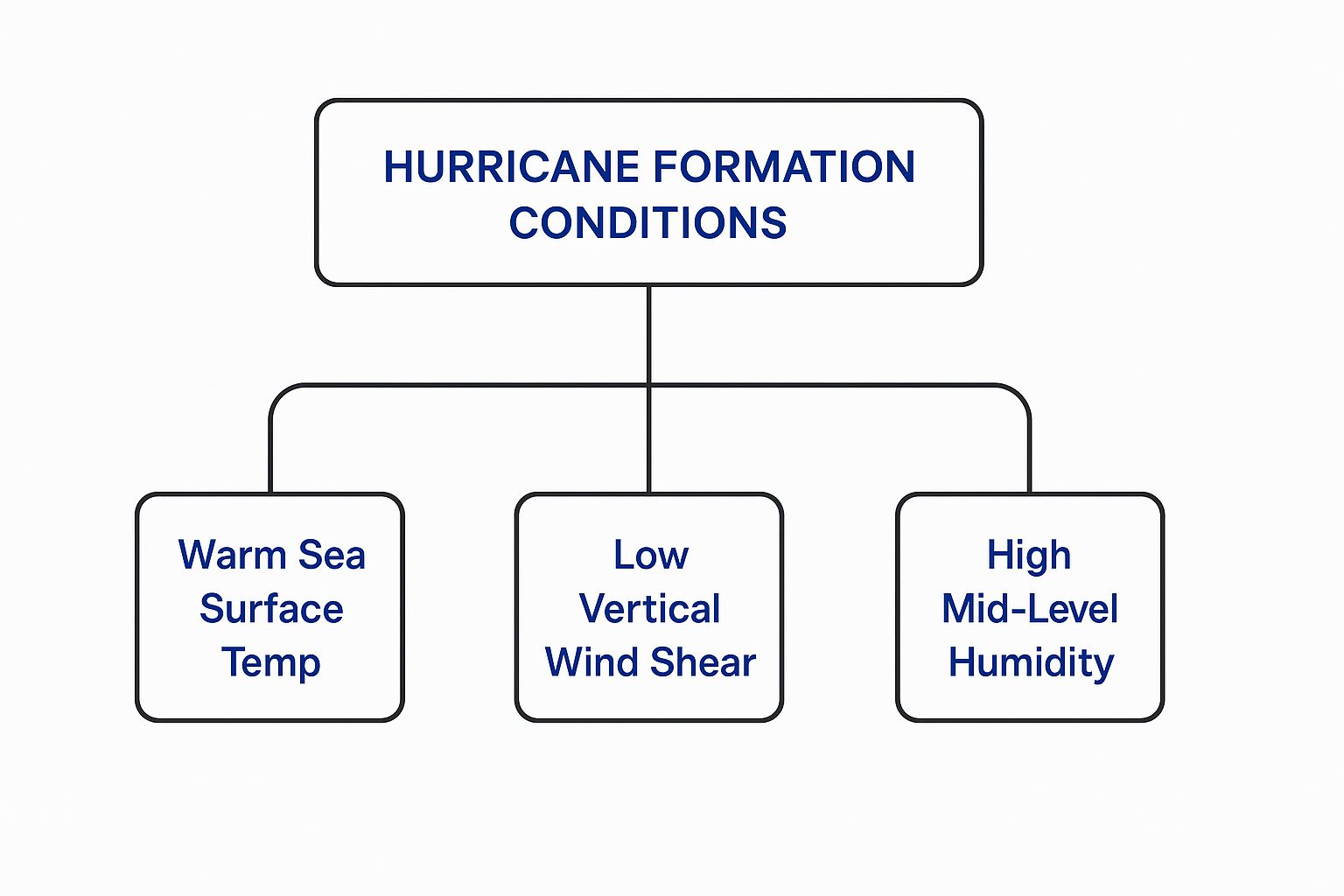
This powerful trio works in concert: warm water provides the raw fuel, high humidity sustains the engine, and low wind shear creates the stable, organized structure needed for growth. Without all three, a storm cannot achieve its destructive potential.
To put it all together, here’s a summary of the six essential ingredients needed to initiate a tropical cyclone.
Hurricane Formation Checklist At a Glance
| Condition | Required Threshold | Role in Storm Formation |
|---|---|---|
| Warm Ocean Water | 80°F (26.5°C) down to 150 feet deep | Provides the heat energy (latent heat) that fuels the storm's engine. |
| Atmospheric Instability | Warm, moist air near the surface; cooler, drier air aloft | Allows air parcels to rise freely, driving powerful thunderstorm development. |
| High Humidity | High moisture content through the mid-troposphere | Keeps the storm's core saturated, preventing dry air from weakening it. |
| Coriolis Force | At least 5° latitude (about 300 miles) from the equator | Initiates the cyclonic spin required for the storm to organize and rotate. |
| Low Vertical Wind Shear | Minimal change in wind speed/direction with height | Keeps the storm's vertical structure intact, allowing it to strengthen. |
| Pre-Existing Disturbance | A tropical wave or other low-pressure system | Provides the initial "seed" of low pressure and convergence for the storm to build upon. |
This checklist illustrates why regions like the Gulf of Mexico in late summer become prime hurricane breeding grounds. All necessary conditions are present, waiting for a trigger to set the process in motion.
Disclaimer: ClimateRiskNow provides data-driven insights for educational and risk assessment purposes. We do not sell insurance or provide financial advice. All decisions based on this information are the sole responsibility of the reader.
How Warm Ocean Water Fuels a Hurricane's Engine
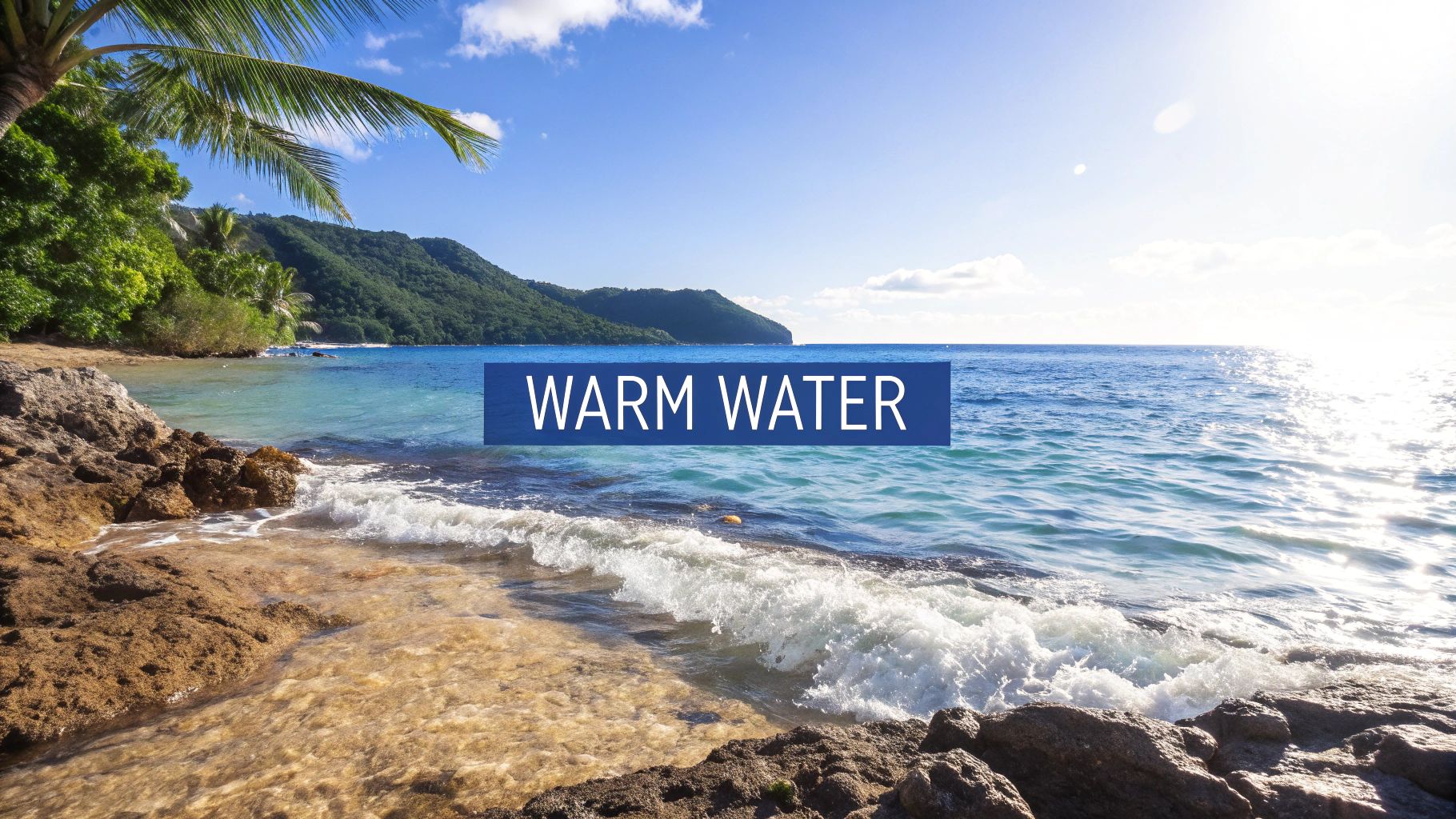
A hurricane is a colossal heat engine, and its primary fuel is warm ocean water. This is the single most important ingredient for a tropical cyclone. Without it, a storm cannot organize, let alone sustain its immense power.
For a storm to form, sea surface temperatures must reach a critical threshold, generally accepted to be at least 26.5°C (80°F). This warm surface layer provides the heat and moisture needed to power the initial thunderstorm clusters, allowing vast amounts of water to evaporate. For a more technical review of a hurricane's internal mechanics, the National Weather Service offers detailed resources.
As that warm, moist air rises and condenses into clouds, it releases an enormous amount of energy called latent heat. This process warms the surrounding air, causing surface pressure to drop and pulling in more air from the surface, feeding the growing system in a powerful feedback loop.
Why Water Depth is So Important
It’s not just the surface temperature that matters; the warmth must extend deep into the ocean. The standard requirement is for water at 80°F to reach a depth of at least 50 meters (about 165 feet).
A storm’s own powerful winds churn the ocean surface. If the warm water is only a shallow layer, the storm will mix it with colder water from below, effectively cutting off its own fuel supply. A deep reservoir of warm water, however, provides a nearly inexhaustible energy source.
For Texas businesses, this is a critical operational risk factor. The Gulf of Mexico is notorious for its deep, warm currents, creating a perfect breeding ground for storms to undergo rapid intensification—a dangerous process where a hurricane’s wind speeds jump by at least 35 mph in just 24 hours.
Rapid Intensification and Its Impact on Texas
This deep-water fuel is precisely what makes storms like Hurricane Harvey so devastating. A storm moving over these super-heated waters can explode in strength just before making landfall, dramatically shortening the preparation window for coastal petrochemical plants, sprawling construction sites, and logistics hubs.
Understanding "ocean heat content" is not merely academic; it is a direct indicator of a storm’s maximum potential intensity. Monitoring this data allows your organization to better assess the ceiling for a developing storm's strength and adjust operational readiness accordingly. To better understand this phenomenon, it's worth reviewing the lessons learned from Hurricane Harvey's impact on Texas industries.
Wind Shear and Atmospheric Stability: The Invisible Forces
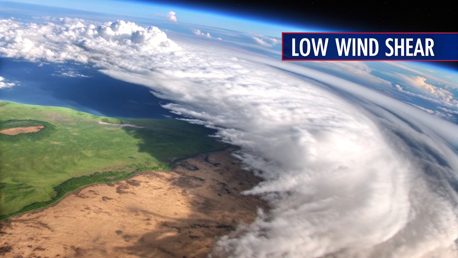
While warm ocean water provides the raw fuel for a hurricane, atmospheric conditions determine if the engine can start. Two of the most critical factors are vertical wind shear and atmospheric stability. They dictate whether a simple cluster of thunderstorms can organize into a powerful, rotating cyclone.
For Texas business leaders, understanding these concepts adds crucial context to seasonal forecasts and assists with long-range operational planning.
Think of a developing hurricane as a massive, spinning tower of air. Vertical wind shear is the change in wind speed and direction with height. High wind shear acts like a crosswind, tearing the storm’s fragile structure apart before it can organize and scattering its heat and energy.
Conversely, low wind shear allows the storm to build vertically, maintaining its structure and efficiently drawing heat from the ocean. A calm upper-level environment is a non-negotiable requirement for a hurricane to form and intensify.
The Role of Atmospheric Stability
Atmospheric stability determines whether air is inclined to rise or sink. For a hurricane to form, the atmosphere must be unstable, meaning a pocket of warm, moist air at the surface will continue rising on its own if given an initial nudge.
This process is essential for creating the towering thunderstorms that form a hurricane's core.
- Unstable Air: Warm, humid air near the ocean is less dense than the cooler, drier air above it. This natural buoyancy allows it to rise freely, releasing huge amounts of latent heat that power the storm.
- Stable Air: If the atmosphere is stable, any rising air quickly becomes cooler than its surroundings and sinks, placing a lid on thunderstorm development.
A key example of a stabilizing force is the Saharan Air Layer (SAL)—a mass of dry, dusty air that moves off the coast of Africa. When the SAL pushes over the Atlantic, it suppresses hurricane activity by injecting dry, stable air and increasing wind shear, starving potential storms of the moisture they need.
Understanding these atmospheric dynamics is key to anticipating risk. Knowing the current wind shear patterns over the Gulf of Mexico can explain why one disturbance dissipates while another intensifies overnight. These are just a few of the many factors that can impact business operations; you can explore more natural risk examples and their business implications in our detailed guide.
Why Hurricanes Need Spin From the Coriolis Effect

A cluster of thunderstorms, no matter how powerful, needs to rotate to become a hurricane. This critical spin is initiated by an invisible but powerful force called the Coriolis effect.
The Earth's rotation deflects moving objects—including wind—to the right in the Northern Hemisphere and to the left in the Southern Hemisphere. This deflection is what transforms a chaotic weather disturbance into an organized, rotating cyclone. As air rushes toward the low-pressure center of a developing storm, the Coriolis effect gives it a constant nudge, forcing the entire system into the signature counter-clockwise spin seen in our hemisphere.
The Equatorial “No-Go Zone”
The Coriolis effect is weakest at the equator and grows stronger toward the poles. This creates a "no-go zone" for tropical cyclone formation.
Storms cannot form within about 5 degrees latitude of the equator, a band extending roughly 345 miles north and south. In this zone, the Coriolis effect is too weak to initiate rotation. Without this essential force, thunderstorm clusters may develop but will not organize into the cyclonic engine required for hurricane development. You can get a deeper look at the mechanics in this breakdown of the science of tropical cyclones.
What This Means for Texas Businesses
For any Texas company in logistics, shipping, or energy, this is a fundamental principle of risk management. It explains why storms threatening the Gulf of Mexico almost always originate in the Atlantic or the Caribbean, where the Coriolis force is strong enough to organize them.
This geographic reality means storm tracks are not random. The Coriolis effect, combined with prevailing steering winds, creates predictable corridors for hurricane movement. By understanding these fundamental physics, your business can better assess route viability, anticipate supply chain disruptions, and strategically position assets long before a storm approaches.
The Spark That Ignites the Storm
A hurricane requires a spark to ignite. Even with ideal conditions—warm water, low wind shear, and high moisture—a storm will not form without a pre-existing weather disturbance to act as its seed.
These disturbances are clusters of thunderstorms that create a localized area of lower air pressure. This initial low-pressure zone provides a focal point for surrounding winds to converge, initiating the cyclonic spin that can evolve into a hurricane.
Common Origins of Hurricane Seeds
For businesses in Texas and along the Gulf Coast, the most important source of these storm seeds originates halfway across the globe. The primary triggers for major Atlantic hurricanes are tropical waves, also known as African Easterly Waves.
These are ripples of low pressure that form over North Africa. During the peak of hurricane season, a new wave moves west across the Atlantic every three to four days.
- Journey Across the Atlantic: As these waves travel over the warm tropical ocean, they encounter ideal conditions to organize and strengthen.
- Significant Threat Source: A staggering 60% of all Atlantic tropical storms and minor hurricanes originate as tropical waves. Critically, they are the seed for about 85% of all major hurricanes—the Category 3, 4, and 5 storms that pose the greatest threat to business operations.
This trans-oceanic journey provides significant lead time to monitor a system’s potential. A tropical wave leaving Africa is a trackable risk that must be watched closely as it moves toward North America, allowing for proactive planning.
Other Triggers Closer to Home
While waves from Africa are the primary source, other disturbances can ignite storms much closer to the Gulf Coast. A decaying cold front can stall over the warm waters of the Gulf of Mexico, providing enough atmospheric lift and spin to generate a tropical system.
These "homegrown" systems can be particularly dangerous for Texas industries. Because they form nearby, the lead time from a newly formed disturbance to potential landfall can be dangerously short—sometimes just a matter of days. This drastically shrinks the window for activating emergency plans, securing job sites, and rerouting supply chains.
Understanding a storm's origin transforms hurricane preparedness from a reactive scramble into a proactive strategy. By tracking these initial sparks, your organization can get ahead of potential threats and execute your plans with greater confidence. A well-defined strategy, like our hurricane season preparation checklist, can make a critical difference.
Translating Weather Science Into Business Preparedness
Knowing what conditions are needed for hurricanes to form is the foundation of effective operational risk management for any Texas business. This knowledge is key to shifting from reactive crisis management to proactive, data-driven mitigation. When you understand why the deep, warm waters of the Gulf of Mexico can rapidly intensify a storm, the need for hardened infrastructure and well-drilled emergency procedures becomes clear.
This scientific insight directly informs real-world risk management. A logistics company tracking tropical waves from Africa gains extra days to reroute critical supply chains. A construction firm that understands the threat of "homegrown" Gulf systems can implement faster site security protocols. A manufacturing plant can schedule preventative shutdowns with greater confidence, minimizing both risk and financial loss.
From Theory to Actionable Strategy
This knowledge drives critical actions for Texas industries:
- Securing Infrastructure: Reinforcing facilities, elevating essential equipment, and ensuring backup power systems are tested and ready long before a storm forms.
- Protecting Job Sites & Assets: Implementing clear protocols for securing materials, equipment, and personnel at exposed sites, such as construction projects or agricultural operations.
- Continuity Planning: Building detailed business continuity plans that account for disruptions to power, transportation, supply chains, and employee availability.
The core principle is simple: the more you understand the threat, the better you can prepare for its impact. A well-informed strategy minimizes downtime, protects assets, and ensures a faster return to normal operations post-storm.
This level of understanding empowers decision-makers to safeguard their operations against the unique weather threats in Texas. By integrating these scientific insights into your planning, you create a more resilient organization. For a deeper look at tactical steps, review our comprehensive guide on hurricane preparedness for businesses.
Disclaimer: ClimateRiskNow provides data-driven insights for educational and risk assessment purposes. We do not sell insurance or provide financial advice, and all decisions based on this information are the sole responsibility of the reader.
Common Questions About Hurricane Formation
For business leaders managing operational risk during hurricane season, a few key questions consistently arise. Getting clear, practical answers is the first step toward building a robust plan to protect your facilities and maintain supply chain integrity.
Why Does the Gulf of Mexico Fuel Rapid Intensification?
The Gulf of Mexico acts as a high-octane fuel tank for hurricanes. It contains deep pools of exceptionally warm water, which is pure energy for a developing storm.
When a storm moves over this "fuel" and atmospheric conditions like low wind shear are also present, it can undergo rapid intensification. This is one of the biggest threats to coastal Texas, as a storm can escalate from a manageable Category 1 to a catastrophic Category 4 in less than a day. This drastically shortens the time available to secure assets, execute shutdown procedures, or ensure personnel safety.
Can a Hurricane Form Over Land?
No. Hurricanes are heat engines that depend entirely on the moisture and energy provided by warm ocean water.
Once a storm makes landfall, it is cut off from its power source and begins to weaken. However, the dangers from destructive winds, storm surge, and especially inland flooding can extend for hundreds of miles, threatening logistics hubs, manufacturing facilities, and agricultural operations far from the coast.
How Do Seasonal Forecasts Work?
Seasonal forecasts provide a high-level strategic outlook for the hurricane season. Forecasters analyze large-scale climate patterns, such as El Niño or La Niña, and broad trends in sea surface temperatures to assess risk.
The goal is not to predict specific storm landfalls but to determine if the overall environment will be more or less favorable for storm formation over the entire season. For business leaders, these forecasts serve as a strategic planning tool. They help gauge the potential risk level for the coming months and inform decisions on when to ramp up preparations. Mastering how to prepare for hurricane season is how you turn these long-range outlooks into concrete, protective actions.
At ClimateRiskNow, we deliver actionable weather intelligence that helps Texas businesses move from reacting to weather to proactively managing it. Our Sentinel Shield platform translates complex meteorological data into clear, strategic guidance to help you build a more resilient operation.