
The Google Weather API is a technical tool that delivers real-time, forecast, and historical weather data for any location on the planet. For industries across Texas—from Energy and Manufacturing to Logistics and Construction—it provides programmatic access to the granular meteorological data essential for day-to-day operational planning and long-term risk mitigation. This data stream helps companies assess and prepare for severe weather, turning raw information into an actionable operational advantage.
Why the Google Weather API is a Key Tool for Texas Operations
For executives and operational managers in Texas, managing the constant threat of extreme weather is a fundamental business challenge. Integrating precise, automated weather data is no longer optional; it is a necessity for maintaining safety, operational efficiency, and profitability. The Google Weather API acts as a direct feed for this critical intelligence.
As part of the Google Maps Platform, the API supplies a continuous stream of global weather data. It offers current conditions, hourly and daily forecasts, and historical weather records, with information refreshing approximately every 15 to 30 minutes. For instance, a 2021 winter storm cost the Texas economy an estimated $80-$130 billion, highlighting the severe financial impact of inadequate preparation. Access to near real-time data allows for dynamic operational adjustments to mitigate such risks.
This data-driven approach enables Texas companies to shift from a reactive posture to one of proactive preparation. By feeding API data directly into existing business intelligence systems, organizations can automate alerts, optimize schedules, and secure assets long before a storm makes landfall.
The operational benefits are concrete and immediate:
- Enhanced Safety Protocols: Construction and energy companies can use real-time wind and lightning data to suspend high-risk work, protecting personnel and complying with OSHA guidelines. For example, crane operations are typically suspended when wind speeds exceed 30 mph.
- Optimized Logistics: Supply chain managers can reroute trucks and shipments based on hyperlocal storm forecasts, avoiding costly delays and maintaining delivery schedules along critical corridors like I-35.
- Informed Agricultural Decisions: Farmers and agricultural managers can use precipitation and temperature forecasts to optimize irrigation and planting schedules, maximizing crop yields and conserving water resources, a critical concern given Texas's susceptibility to drought.
Understanding the full spectrum of threats is the first step in building a resilient operation. You can learn more by reviewing these common examples of natural disaster risks for businesses.
Disclaimer: ClimateRiskNow provides this information for educational purposes only. We do not sell insurance or financial products, and this content should not be interpreted as financial advice. Our goal is to empower Texas businesses with data-driven insights for operational risk management.
Getting Started with API Access and Setup
To begin using the Weather Google API, a setup process within the Google Cloud Platform is required. This initial step provides secure access to the weather data that will power your risk management strategy. The process is designed to be manageable for both technical teams and business leaders.
The first step is to create a new Google Cloud project or select an existing one. This project serves as a centralized hub for managing all related services, billing, and permissions for your API usage.
Enabling the API and Generating Your Key
With a project established, the next step is to enable the Weather API, located in the Google Maps Platform library. This action authorizes your project to request weather data. Subsequently, you will generate a unique API key, which is the essential credential for authenticating your requests.
The process involves three core steps:
- Create or Select a Project: Log into the Google Cloud Console to set up a project for your weather data integration.
- Enable the Weather API: Navigate to the API Library, locate the "Weather API" under the Google Maps Platform, and enable it for your project.
- Generate Credentials: From the "Credentials" page, create a new API key and securely store it for use in your application.
Securing Your API Key
Securing your API key is a non-negotiable component of responsible API management and a cornerstone of any effective operational risk management framework. An exposed key can lead to unauthorized use, resulting in unexpected costs and potential service disruptions.
A crucial best practice is to restrict your API key to prevent misuse. Implement application restrictions (e.g., limiting it to specific IP addresses or HTTP referrers) and API restrictions. This ensures the key can only be used for authorized services, such as the Weather API.
This security measure ensures your access remains under your control, preventing unauthorized queries from impacting your budget or data quotas. Properly configured credentials form the foundation of a reliable and cost-effective weather intelligence system.
Navigating Key API Endpoints and Data Types
To translate raw weather data into actionable operational intelligence, it is essential to understand the core functions of the Weather Google API. The API is structured around specific endpoints, each designed to deliver a different type of weather information. For any Texas business, selecting the correct endpoint is the first step in building a weather-aware operational plan.
The API provides four main endpoints covering different planning horizons and needs, allowing you to retrieve precisely the data required without extraneous information.
Current Conditions and Hourly Forecasts
The /currentConditions endpoint provides a real-time snapshot of the weather for a specific location. This is critical for tactical, on-the-ground decisions. A construction site manager in Houston, for example, can use this endpoint to monitor wind speeds and suspend crane operations if gusts become hazardous.
For short-term planning within a single workday or week, the /forecast endpoint can be configured to retrieve hourly data, offering a 240-hour (10-day) lookahead. A logistics company could use this level of detail to adjust delivery routes in the Dallas-Fort Worth area, steering trucks away from predicted afternoon thunderstorms that frequently disrupt traffic.
These endpoints provide key data points such as:
- Temperature and "Feels Like" Temperature: Essential for managing heat exposure for outdoor workers and predicting energy demand for facilities.
- Precipitation Probability and Type: Informs decisions on everything from pouring concrete on a job site to scheduling crop irrigation.
- Wind Speed and Direction: Critical for safety protocols in logistics, petrochemical operations, and construction.
- UV Index: A key metric for agricultural planning and ensuring worker safety during peak sun hours.
Daily Forecasts and Historical Lookbacks
The same /forecast endpoint can also deliver a 10-day daily forecast. This longer-term view is invaluable for strategic planning, such as scheduling a multi-day construction project or managing inventory for an agricultural business ahead of a predicted freeze. It helps decision-makers anticipate major weather systems and allocate resources accordingly.
Finally, the /history endpoint allows you to access hourly weather data for the past 24 hours. While the range is limited, it is extremely useful for incident analysis. If equipment failed at a remote energy facility, this historical data can help determine if weather—such as a lightning strike or extreme temperatures—was a contributing factor. This data supports post-event reviews and enhances future preparedness.
The table below summarizes the capabilities of each endpoint and their common applications for Texas industries.
Weather Google API Endpoint Capabilities
| Endpoint | Forecast/Data Range | Key Data Parameters | Primary Use Case for Texas Industries |
|---|---|---|---|
/currentConditions |
Real-time | Temp, wind, precipitation, UV Index | Immediate operational safety (construction, energy) |
/forecast (Hourly) |
Up to 240 hours | Hourly temp, wind, rain probability | Short-term scheduling and logistics route optimization |
/forecast (Daily) |
Up to 10 days | Daily high/low temp, weather summary | Strategic planning, resource allocation, inventory management |
/history |
Past 24 hours | Hourly temp, wind, precipitation | Incident analysis and post-event operational reviews |
This table serves as a quick reference for matching the right API tool to a specific operational challenge, whether managing a petrochemical plant on the Gulf Coast or a distribution center in Dallas.
As you plan the scale of your integration, it is also important to understand the daily request quotas for different API tiers. The chart below provides a clear overview.
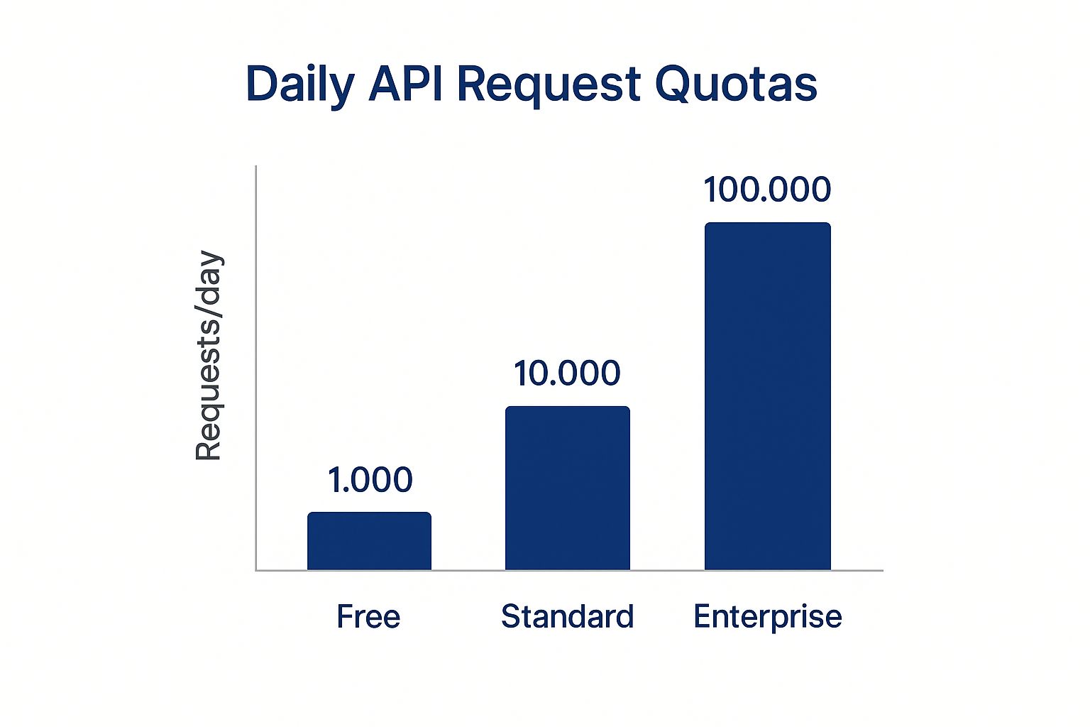
This demonstrates the API's scalability, allowing businesses to start with a smaller implementation and expand data usage as they integrate weather intelligence more deeply into their daily operations.
Integrating Weather Data into Your Business Systems

Obtaining an API key is the initial step. The true value is realized when you channel that raw weather data directly into the systems that drive your daily operations. This is where the Weather Google API transforms from a data source into a powerful operational tool.
By feeding this information into your existing business intelligence (BI) platforms, custom dashboards, and other enterprise software, you can convert data into actionable insights. For Texas industries, this means automating responses to weather threats, thereby enhancing both safety and efficiency.
Consider a logistics company integrating hourly forecasts into its routing software. The system could automatically redirect trucks around developing thunderstorms, avoiding costly delays without manual intervention. Or a large-scale agricultural operation connecting precipitation forecasts to its irrigation systems, conserving significant water resources while protecting crop health. This represents a shift from manual monitoring to proactive, automated risk management.
The process involves parsing the API’s JSON response and mapping specific data points—like wind speed or temperature—to triggers within your own software. This setup enables automated alerts and data-driven operational shifts.
Making an API Call
To retrieve weather data, your system sends an HTTP GET request to the appropriate API endpoint. The request must include your unique API key and the precise latitude and longitude of the location of interest. The API then returns a structured JSON object containing the requested weather information.
Here is a conceptual Python example demonstrating how to request current conditions for a specific location.
import requests
Define API parameters
api_key = "YOUR_API_KEY"
latitude = 30.2672 # Example: Austin, TX
longitude = -97.7431
Construct the API request URL
Make the request and print the response
response = requests.get(url)
weather_data = response.json()
print(weather_data)
This simple script fetches the data, which can then be processed to extract key values like temperature, precipitation, or wind speed for use in your operational systems.
Practical Integration Examples for Texas Industries
Connecting this data flow directly to your operational platforms provides significant competitive advantages. The objective is to make your systems "weather-aware" to support smarter, faster decisions with less need for constant human oversight.
- Manufacturing: Integrate real-time temperature and humidity data with your facility’s HVAC controls to maintain optimal production conditions and prevent equipment damage from overheating.
- Construction: Feed wind speed forecasts into project management dashboards to automatically flag high-risk days for crane operations or work at heights, ensuring compliance with safety standards.
- Energy: Use real-time lightning strike data to trigger automated safety alerts for field crews at remote sites, dramatically improving worker safety in the Permian Basin and other regions.
- Logistics: Maintaining operational uptime is critical. You can learn more about building weather-resilient supply chains in our guide on improving supply chain resilience against extreme weather.
The true value of the Weather Google API is realized when it becomes an integrated component of your operational nervous system, allowing your business to sense and respond to environmental changes with precision and speed.
For a deeper dive into creating a dedicated interface, explore our resources on building a custom weather risk dashboard.
Disclaimer: ClimateRiskNow provides this information for educational purposes only. We do not sell insurance or financial products, and this content should not be interpreted as financial advice. Our goal is to empower Texas businesses with data-driven insights for operational risk management.
Using Historical Weather Data for Risk Analysis
While real-time forecasts are essential for tactical operational decisions, historical weather data offers a powerful strategic advantage for long-term risk assessment. By analyzing past weather events at specific asset locations, Texas businesses can identify trends, validate risk models, and develop more resilient operational plans.
This historical analysis provides context for future threats. For example, an energy company can analyze historical temperature spikes and correlate them with equipment failure rates, enabling more accurate predictive maintenance schedules. A logistics firm can analyze past winter storms in North Texas to model their real-world impact on delivery timelines and develop contingency plans.
Strengthening Models with Historical Insights
The most powerful application comes from combining historical weather data from the API with your own internal operational data. This integration allows you to quantify the direct financial impact of specific weather conditions on your business.
- Asset Performance: Analyze how past extreme heat or freeze events affected machinery and infrastructure to inform smarter capital investment and maintenance strategies.
- Supply Chain Integrity: Map historical hurricane tracks against your Gulf Coast supply routes to identify chronic vulnerabilities and develop alternative logistics pathways.
- Workforce Safety: Correlate past weather events with workplace incidents. This is especially critical for outdoor-intensive industries like construction and energy, helping to refine safety protocols based on historical data.
Analyzing past events helps build a data-driven foundation for proactive resilience. This approach moves risk management from reactive measures to a calculated, forward-looking strategy, ensuring better preparation for future climate volatility. Our detailed guide on hurricane preparedness for businesses demonstrates how this historical context can be put into practice.
Historically, weather APIs have evolved from providing sparse data to offering comprehensive global insights. The weather Google API advances this by integrating AI models with traditional forecasting, supported by a historical dataset updated every six hours and accessible through platforms like BigQuery for large-scale analysis. You can learn more about how AI-driven models improve forecasting accuracy at openweathermap.org.
Disclaimer: ClimateRiskNow provides this information for educational purposes only. We do not sell insurance or financial products, and this content should not be interpreted as financial advice. Our goal is to empower Texas businesses with data-driven insights for operational risk management.
Managing API Costs and Budgeting for Usage
For any Texas business leader, integrating a new data stream like the Google Weather API requires a clear understanding of the financial commitment. The API utilizes a scalable, pay-as-you-go pricing model, allowing companies to start with a small-scale pilot, prove its operational value, and then expand usage without a significant upfront investment.
The cost-per-call framework makes budgeting straightforward. A Texas logistics firm tracking a large fleet or an agricultural operation monitoring multiple fields can estimate usage by multiplying the number of locations by the required data refresh frequency. This provides a predictable monthly expense.
Understanding the Cost Structure
The API's tiered model is advantageous, particularly for high-volume users. Currently in a no-charge Preview phase, its future pricing is designed to be cost-effective.
- Free Tier: The first 10,000 calls each month are provided at no cost.
- Tiered Pricing: Beyond the free tier, the cost per call decreases with volume, starting at $0.15 per 1,000 calls and dropping to $0.04 per 1,000 calls for high-volume needs.
This model is remarkably affordable compared to other Google Maps Platform services. For instance, the widely used Geocoding API costs approximately $5.00 per 1,000 calls, making the Weather API about 33 times more cost-effective per transaction. More details can be found on Google's API pricing models at afi.io.
Integrating this data with sound financial planning is a crucial part of a robust operational strategy. To understand how this fits into a broader risk management framework, review our guide on the best available climate risk assessment tools.
Common Questions About the Weather API

When Texas business leaders evaluate the weather Google API, several key questions consistently arise. This section addresses those common queries to clarify how this tool can be effectively applied in industries facing significant weather risks, such as energy, logistics, agriculture, and construction.
The goal is to provide the clarity needed to leverage this tool for smarter, data-driven decisions when it matters most.
How Accurate Is The API For Localized Texas Weather?
The API’s hyperlocal accuracy for specific Texas locations is one of its primary strengths. It aggregates data from multiple trusted meteorological sources and processes it through a proprietary model to deliver highly localized insights.
The data is refreshed approximately every 15 to 30 minutes. This frequent update cycle is critical for tracking Texas’s volatile weather patterns, from sudden Gulf Coast thunderstorms to severe West Texas dust storms. For a logistics company routing trucks near Dallas or an energy firm monitoring assets in the Permian Basin, this level of temporal detail is essential for maintaining safety and operational continuity. The API’s hybrid model, which blends AI with physics-based modeling, delivers a more nuanced and reliable forecast at the asset level.
What Is The Main Difference From Traditional Weather Models?
The key differentiator is the combination of AI and the massive scale of Google's data infrastructure. While traditional meteorological models are reliable, the Google Weather API adds an analytical layer that was refined on Google Search for over a year before its public release.
- AI-Enhanced Forecasting: The model continuously learns and adjusts to provide more accurate predictions for the complex weather phenomena common in Texas, such as flash floods or hail events.
- Data Integration: It is designed for seamless integration within the Google Cloud ecosystem, making it easy to combine with other geospatial tools for deeper, multi-layered risk analysis.
- Scalability: Operating on Google's global infrastructure ensures reliable data delivery, even during major storm events when demand for weather information surges.
Can It Integrate With Existing GIS Platforms?
Yes, the API is designed for straightforward integration with existing Geographic Information Systems (GIS) like ESRI's ArcGIS. It delivers weather data via standard web protocols, and its JSON output is easily consumable by virtually any modern GIS platform.
This capability allows you to overlay real-time and forecast weather data directly onto your operational maps. Imagine a construction firm visualizing wind speed forecasts on a digital twin of a job site, or an agricultural business mapping rainfall data over specific fields to optimize irrigation. This integration makes complex data immediately actionable for planners and field managers.
Disclaimer: ClimateRiskNow provides this information for educational purposes only. We do not sell insurance or financial products, and this content should not be interpreted as financial advice. Our goal is to empower Texas businesses with data-driven insights for operational risk management.
Ready to turn weather data into a competitive advantage? At ClimateRiskNow, we deliver location-specific risk intelligence to help Texas industries prepare for and mitigate the impacts of extreme weather. Our assessments provide the actionable data needed to protect your assets and maintain operational continuity.
Request a demo of our tailored weather risk assessments today.